

It’s easy to forget just how beautiful Earth really is, especially when the vast majority of us never get to see this blue marble from afar. But photos from The National Oceanic and Atmospheric Administration are reminding us of this planet’s beauty and providing more accurate weather forecasts.
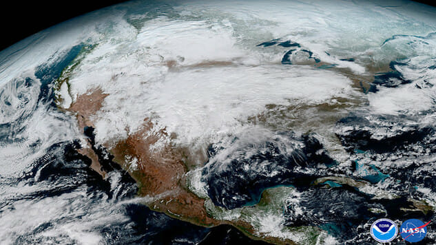
The National Oceanic and Atmospheric Administration released images taken by the recently launched GOES-16 satellite that show images of earth that are more detailed than any images before.
Launched in November, the satellite uses a high-definition camera to observe Earth and provide better weather forecasts while orbiting the planet at approximately 22,300 miles above Earth. According to NOAA, GOES-16 is the first in a series of geostationary weather satellites and can provide images of the full Western Hemisphere every 15 minutes, and images of the continental United States every five minutes.
Compared to previous GOES satellites orbiting earth, the GOES-16 can scan the planet five times faster and provide four times the image resolution. For meteorologists, this provides much more effective tools in forecasting and understanding weather patterns.
GOES-16 will now be able to contribute more to NOAA’s hurricane tracking and its severe-weather forecasting and monitoring.
Steven Goodman, NOAA’s senior scientist for the GOES-R series explained that “it’s more than a pretty picture”. The technology will provide valuable insight into atmospheric conditions and their impacts on the Earth and its inhabitants.
Top photo courtesy of The National Oceanic and Atmospheric Administration
Lauren Leising is a freelance writer based in Athens, Georgia.